Natural Channel Design
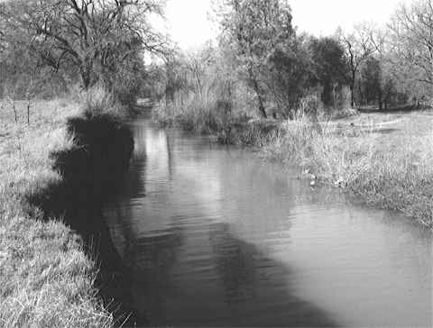
| By John McCullah and Rose Sloan (This paper will be presented at the Annual IECA Conference in Las Vegas, 2001, and also published in the conference proceedings) ABSTRACT In 1997 the Sacramento Watersheds Action Group (SWAG) conducted an assessment of the Sulphur Creek Watershed, a tributary to the Sacramento River. The analysis included documentation of land uses, an inventory of erosion and sediment sources, an analysis of riparian conditions and stream habitat, and a preliminary hydrologic analysis. The watershed analysis revealed that extensive dredger mining, road building, and railroad construction within the Sulphur Creek watershed - combined with dam releases which caused backwater conditions at the mouth of Sulphur Creek - have resulted in channel degradation and severe deterioration of fisheries and wildlife habitat. The erosion inventory for this analysis was an important step in making recommendations for watershed restoration projects. The erosion inventory indicated that streambank erosion within the lower reaches of Sulphur Creek (also the location of the Redding Arboretum) is the primary source of sediment negatively impacting adjacent spawning areas. Near the confluence with the Sacramento River, a 200 m (600 ft) segment of Sulphur Creek became a depositional area for sediment. A median sandbar resulted from the combined effects of these sediment inputs and the backwater from the River. This caused the channel to "jump" over into an open meadow, forming a high vertical bank that was eroding at an alarming rate. Using the watershed analysis as a basis, SWAG, with the assistance of Shasta College students, embarked on a project to return the stream to its "historic" channel. The project was to be implemented as a community-based, worksite learning opportunity for the Shasta College Watershed Restoration and Heavy Equipment Operations classes. This report discusses the design, implementation, and results of a channel re-alignment project within the Sulphur Creek Watershed. This project involved the removal of a median sandbar, reshaping an eroding vertical bank, and realignment of approximately 200 m (600 ft) of Sulphur Creek. The channel was reconstructed in a meandering alignment while the banks were stabilized with Biotechnical Erosion Control techniques. Fish habitat features were installed, such as boulder clusters, root wads, riparian vegetation, and spawning gravel (which was uncovered during excavation of the sandbar). The dynamics of the new channel changed dramatically during the wet winter following the realignment. These changes have led to unique results as the channel reaches equilibrium. The total cost for this project was originally estimated
at $53,540. However, through extensive volunteer efforts
supported by the local college and in-kind contributions,
the project was completed with only a $3000 mini-grant. BACKGROUND Sulphur Creek is a seasonal urban stream located in Redding,
California. The lower reach of Sulphur Creek is located
within the Redding Arboretum on the River. The confluence
of Sulphur Creek and the Sacramento River is immediately upstream
from some of the most productive spawning areas of endangered
runs of Chinook salmon. This reach of the Sacramento
River in Northern California is known as the “Redding
Redds”. The mouth of Sulphur Creek is also near
the northern entrance to the Turtle Bay Pedestrian Bridge,
an unusual harp-shaped suspension bridge that is currently
under construction. Once completed, the bridge will
offer a link from the new Turtle Bay Museum complex to the
educational natural resources within the Arboretum.
Sulphur Creek provides spawning and rearing habitat for Chinook
salmon, steelhead, and rainbow trout, and an urban setting
offers the unique opportunity for public viewing of these
salmonids. PROBLEM ANALYSIS The lower segment of Sulphur Creek is greatly influenced by backwater effects from the Sacramento River. When the Shasta Dam is discharging 1200 m3/sec (40,000 cfs) or higher, Sulphur Creek forms a backwater “lake” from the mouth to approximately 200 m (600 ft) upstream. It is highly likely that over the last two decades a period of high water coincided with a period of high sediment discharge within the Sulphur Creek watershed. This large sediment discharge most likely came from the excessive streambank erosion through the Arboretum area as a result of the historic stream diversions through dredger tailings. The large discharge of sediment was then deposited as the current velocities slowed in the backwater area. This deposition caused a large median sandbar to be formed. Over the ensuing years conditions were apparently favorable for the establishment of willow, wild grape, non-native blackberry, and other vegetation on the sand bar. The vegetation, with their strong root systems, reinforced the median bar and made it resistant to erosion. During subsequent years, high, flashy discharges within Sulphur Creek (possibly influenced by urbanization) coincided with relatively low flows within the Sacramento River. During these periods, Sulphur Creek had sufficient stream energy to downcut and incise the median bar. However, with the vegetation strongly reinforcing the sand bar, the stream energy was focused onto the right bank (if looking downstream), resulting in the erosion which formed the high vertical bank along this area of Sulphur Creek.
In 1997, SWAG, Shasta College, Turtle Bay Museums, and the Redding Arboretum on the River implemented an emergency streambank stabilization project with the aid of a National Fish and Wildlife Foundation grant along this reach to 1) immediately protect historic oak trees that were being undermined and 2) protect the toe of the eroding bank by using biotechnical erosion control techniques such as vegetated deflectors and vegetated geoberm revetments. The project successfully demonstrated the use of biotechnical methods with rootwads, vegetated rock deflectors, and Salix spp. (willows) as an alternative to traditional hard armoring such as riprap and gabions. The Continuous Berm Machine (CBM) was also used to construct vegetated geoberms with brushlayers to protect the bank between the deflectors. In 1998, SWAG applied for and received a $3,000 mini-grant awarded by the Cantara Trustee Council for installation of in-stream fish habitat improvement structures in this reach of Sulphur Creek. However, while the streambank stabilization effort was successful in stopping erosion at the toe of the vertical bank, monitoring of the completed project revealed that although the 20 foot high bank was no longer being undercut, it was still actively sloughing due to frost wedging and soil saturation. Large chunks of topsoil were still heaving off into the creek below. Other observations affirmed that this section of the channel between the right bank and the aforementioned median bar was preventing the stream from achieving its full potential with regard to natural floodplain processes, and ultimately spawning and rearing habitat. In addition, the reach was classified as an F3 channel (Rosgen Stream Classification System). F3 channel characteristics are not conducive to installation of in-stream fish habitat structures, in most cases. The backwater effect coupled with the somewhat unstable conditions of the F3 channel made selection of habitat structures difficult. This stream reach still did not have a natural or stable alignment or cross-section, and before additional habitat structures or riparian vegetation could be positioned, the channel needed to be aligned into a more natural sinuosity. |
E-mail: info@salixaec.com

© Salix Applied Earthcare